N5DUX's Satellite Guide - Tracking
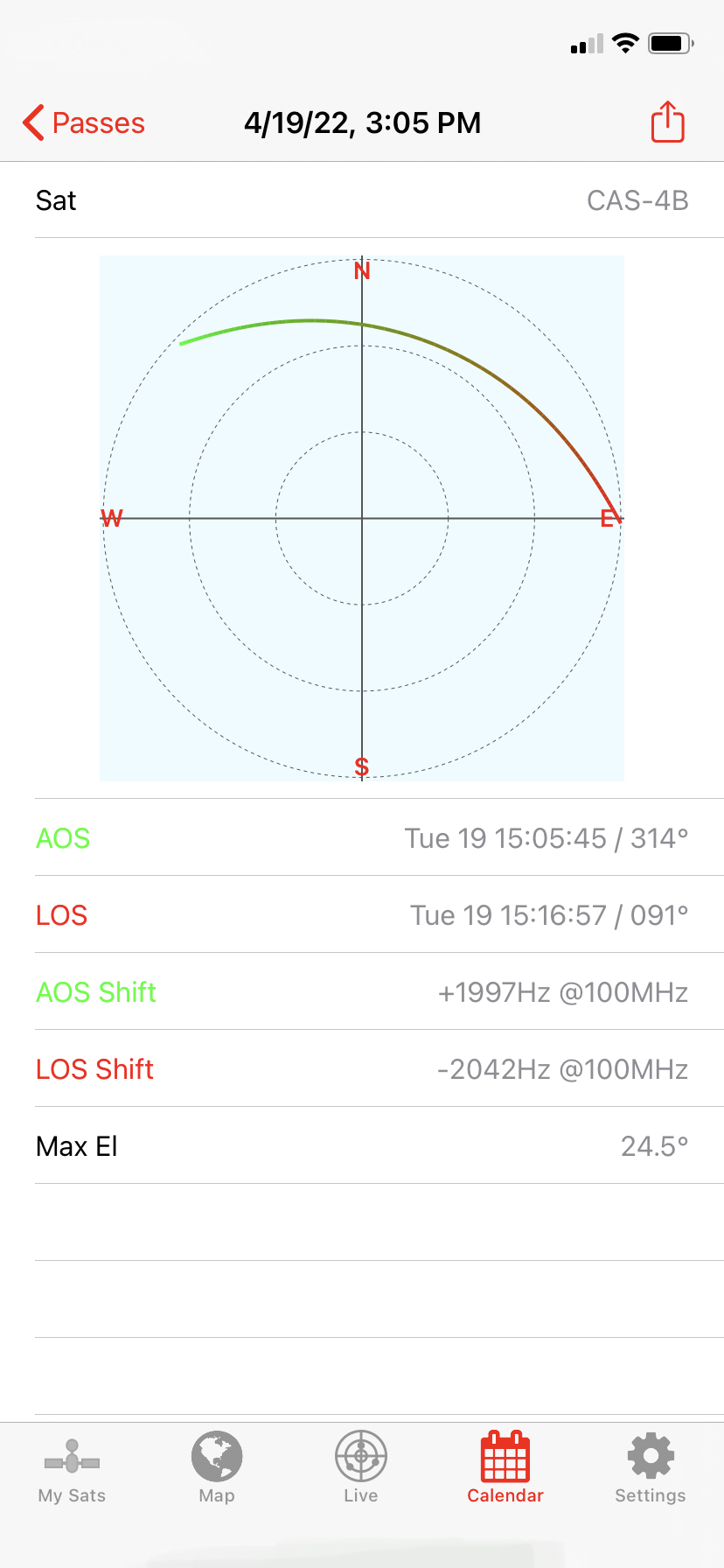
A look at the pass details for CAS-4B in SatSat for iOS
Tracking the satellites in orbit is probably the most important aspect of working satellites. If you don't know where and where to point your antenna, you're going to have a bad time.
I suppose it is possible to listen all the time and get lucky, but that doesn't sound very fun to me!
Tracking
Web-based tracking
There are many ways to find the satellite you want to track, tune, or "work". As I said in the intro at the top, I used to use the website Heavens Above. You put in your latitude and longitude and the website does all the Calculus/geometry to determine when and where the satellite will be for that particular position. Fortunate for you, other options exist too.N2YO has been my go-to website for years. It pulls your location based on your IP address' general location. This has almost always been good enough for my purposes when manually tracking a satellite. It may be off by 1°-2° but my "handheld rotor" has a lot of "slop" and is very forgiving!
Another web-based resource which is not as feature-rich as N2YO, but has been around a very long time is the AMSAT Track page. You set your lat/lon and it will also do all the math for you for whatever satellite you specify.
iOS apps
But this is 2026 and we have smartphones! Smartphone tracking is what every portable/handheld satellite operator uses - at least, the ones I've met - and barring any extenuating circumstances such as on a boat, backpacking/camping "off grid", etc. So, sure, there are times when cell service may not be available, but even then most apps cache the satellite's tracking data (called the Two-Line Elements, or TLEs, for those of you wondering). With that data stored, it's still possible for most apps to track even without cell service.Personally, I've been using SatSat because I'm an iPhone user and it's free. It does just about everything I want it to do. HamSatHD and GoSatWatch are other popular iOS apps for tracking satellites, though each of those are pay-for apps.
Android apps
For Android users, I know Heavens-Above has an app which is popular and W1ANT has an Android app as well, both the free, ad-supported version linked here and a pay-for version without distracting ads.Wiki
Worth mentioning is this wiki that lists satellite tracking apps and which features they offer.Understanding the pass
Azimuth
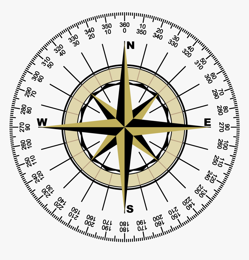
The compass rose
In the age of sail, mariners would use the "winds" to refer to directions we now call North, South, East, and West. But those four cardinal directions are not exacting enough. Those directions would be further divided into northeast, southeast, southwest, and northwest. That might be good enough for directions nearby, but when you're navigating a featureless ocean, it's still not accurate when you factor in how far off you would be after traveling a long distance.
More "winds" were added. You may have heard of north-by-northwest or east-by-southwest - those are meant to convey ever-finer accuracy. Eventually 128 points named were used (Thanks US Navy and British Admiralty!) At that point the language becomes far too cumbersome - solving this issue is the azimuth.
Azimuth is the number of degrees away from a point of reference (North), from 0°~360° (though technically you won't ever reach 360° because it just loops back to 0°)
Pizza Time
The way I've explained it to kids is to imagine a person standing inside a giant pizza. This pizza has 360 slices. The person can point to an object in any direction. Now if you stand in the center of that giant pizza, that person can tell you something is in the direction of 90-"pizza slices". Count up those slices, look up and you'll see what they were pointing at. Obviously instead of pizza slices we use degrees, but the concept remains. If I say "168°", that's more precise (and efficient) than trying to decode "South by Easy. No - not Southeast, South by East."
The key points to remember are 0° is North, 180° is South ("behind you", "do a 180"), halfway in between is 90° or East, and adding 180 to that is 270° or West.
With those primary points memorized, you can quickly determine points in between. "45? Halfway to 90 is 45, so that must be between North and East, ah, it's Northeast!" With a little practice and experience you'll begin to "feel" and know the azimuthal method as surely as you know North, South, East, and West. Because this whole series is about handheld tracking, you just need to get "close enough" to the location of the satellite to be able to find it. You're unlikely to be so precise in your arm movement that it matters if you're truly pointing at 70° and not 80°. Besides, if you're that precise, well, you probably don't have trouble with azimuth anyway.
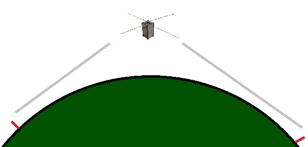
Elevation
The other point of reference needed to locate any celestial object is the elevation (sometimes also called altitude).Elevation is the angle up from the horizon. 0° is the horizon (no rise), 90° is straight up. 45° is halfway to straight up. A little below halfway is 30° and a little above halfway is 60°. With those rough estimates you can easily gauge a satellites location. With that understanding, you can then look at the circular map presented by most tracking software packages. (Refer to the graphic up top)
The concentric rings are:
The point when the path of the satellite crosses into the outer ring is when you can first hear it (AOS) and the point when it crosses the outermost ring is when you'll no longer hear it (LOS).
AOS/LOS
A couple of terms you'll see used quite often in tracking apps is AOS and LOS. These stand for Aquisition Of Signal and Loss Of Signal, respectively. That's when can you first expect to hear the satellite and when can you expect to no longer hear it. Those times are based purely on mathematics given your altitude if you provided that information to the tracker you're using.The tracker cannot, however, predict unique variations of your location. Do you have a house or tree nearby? That will affect your ability to hear the satellite. Is there a mountain range in one direction? That'll affect when you can hear the satellite.
AOS and LOS both occur when elevation is calculated to be at 0°
Low passes are your friend
for making long distance QSOs
for making long distance QSOs
Maximum Elevation
One point of information that sometimes gets overly focused on is the Maximum Elevation. This is the point where the satellite will be highest point of that pass relative to your location. I say it gets overly focused because some people think a pass that is closest to 90° is somehow better. Sure a pass that goes directly overhead might seem easier to work, but there's nothing "better" about a 90° pass versus a 60° pass. In fact, the "low" passes actually give you more range in that direction.
Consider a pass that is 15° off your eastern horizon. How far east is that same pass for someone that sees it at 15° to their west? (A long way!)
If everyone only looked for passes that were higher than 60° for their location, they'd only be making contacts in a limited range. By working low passes, you can really make contacts over great distances. In fact, with some satellites, operators have been able to make trans-Atlantic satellite contacts! It's also entirely possible to make contacts with all 50 states for a Satellite Worked All States award - but it's only possible if you reach for those low passes near the horizon.